Storm Reports API Format

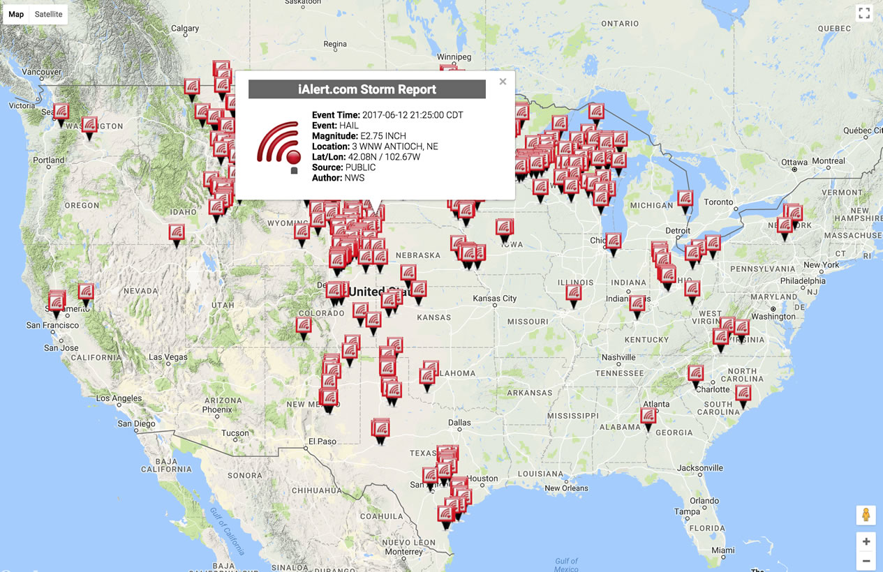
The WxData™ Storm Reports API provides direct access to real-time and historical U.S. storm report data beginning Feb 2013. Storm reports are returned in XML format or map plotted for human analysis. Select from over 25 different report types shown listed below. Reports also contain latitude/longitude or city/state to pinpoint storm event or damage location. Filtering options by date range, magnitude (EG hail size), and national, state, city, or county location offers powerful targeting to receive only those reports that meet your needs.

If you have an existing account using the API Explorer is recommended to build API calls. Additionally, securely passing "key" and "secret" in the http header is supported. Curl example represented below:

curl "https://wxdata.com/cgi-bin/storm-report-api.pl?version=1.0&format=xml&date=2018-03-01T00:00:00&enddate=2018-03-28T00:00:00&state=MD" \
-H "key: [provided-apikey]" \
-H "secret: [provided-secretkey]"

In your API call you can filter on these elements:

  • location
  • date range
  • Event type (Tornado, Hail, Snow amount, ... )
  • Magnitude Confidence (measured, estimated)
  • Magnitude Range

HTTP Methods

API supports GET

Base URL

HTTP: http://wxdata.com/cgi-bin/storm-report-api.pl

HTTPS: https://wxdata.com/cgi-bin/storm-report-api.pl

Request Parameters

The following parameters may be used:

Parameter Description Required Values
version Version control Required 1.0
format Return data format Required
  • Example values:
  • xml
  • plot (map plotted)
key User API access key Required As provided by WxData™
secret Secret key (do not share) Required As provided by WxData™
city City filter, also requires state Optional
  • Example:
  • Boston
  • New+York+City
state Two character state abbreviation Optional
  • Example:
  • AL (ALABAMA)
  • AK (ALASKA)
  • AZ (ARIZONA)
  • AR (ARKANSAS)
  • CA (CALIFORNIA)
county County filter, also requires state Optional
  • Example:
  • Montgomery
  • St+Joseph
date Start date range (YYYY-MM-DDTHH:MM:SS) Required
  • Example:
  • date=2013-06-11T16:00:00 (June 6, 2013)
enddate End date range (YYYY-MM-DDTHH:MM:SS) Required
  • Example:
  • date=2017-06-30T13:00:00 (June 30, 2017)
event Event type Optional
  • Example:
  • tornado
  • funnel+cloud
  • tstm+wnd+dmg (thunderstorm wind damage)
  • tstm+wnd+gst (thunderstorm wind gust)
  • non+tstm+wnd+dmg (non-thunderstorm wind damage)
  • non+tstm+wnd+gst (non-thunderstorm wind gust)
  • lightning
  • downburst
  • high+sust+winds (high sustained winds)
  • hail
  • flood
  • flash+flood
  • rain
  • heavy+rain
  • heavy+snow
  • snow
  • dense+fog
  • dust+storm
  • wildfire
  • hurricane
  • storm+surge
  • tropical+storm
  • rip+currents
  • marine+hail
  • marine+tstm+wind (marine thunderstorm wind)
  • water+spout
mag_confidence Event type magnitude of confidence Optional
  • Example:
  • e (estimated)
  • m (measured)
  • f (fujita scale, tornado only)
mag_range Event type magnitude range Optional
  • Hail Example
  • gt+0.50 (greater than 0.50 inch)
  • gte+0.50 (greater than, equal to 0.50 inch)
  • lt+0.50 (less than 0.50 inch)
  • lte+0.50 (less than, equal to 0.50 inch)
  • eq+0.50 (equal to 0.50 inch)

  • Wind Example
  • gt+25 (greater than 25 mph)
  • gte+25 (greater than, equal to 25 inch)
  • lt+25 (less than 25 inch)
  • lte+25 (less than, equal to 25 inch)
  • eq+25 (equal to 25 inch)

  • Tornado Example
  • gt_2 (greater than F2 tornado)
  • gte_2 (greater than, equal to F2 tornado)
  • lt_2 (less than F2 tornado)
  • lte+2 (less than, equal to F2 tornado)
  • eq+2 (equal to F2 tornado)

Return Elements

Value Description Type
id record id int
city city name text
state Two letter State abbreviation text
county County location of city, state text
latitude latitude of city's zip code location float
longitude longitude of city's zip code location float
event_local_time Local time of reported storm report event YYYY-MM-DD HH:MM:SS
event_local_timezone Local time zone of reported storm report event text
event event type text
magnitude Magnitude of reported storm report event where applicable text
source Reporting source text
remarks Accompanying remarks in storm reports when provided by source text
author Authority that published the storm report on behalf of the source text
subauthor Sub-author of the authority publishing the storm report on behalf of the source text

XML Sample Output

<response xmlns:xsd="http://www.w3.org/2001/XMLSchema" xmlns:xsi="http://www.w3.org/2001/XML-Schema-instance" version="1.2" xsi:noNamespaceSchemaLocation="http://wxdata.com/schema/metar1_2.xsd"> <weatherdata> <time_taken_ms>191</time_taken_ms> <errors/> <warnings/> <data num_results="2"> <storm-report> <id>590807</id> <city>Detroit</city> <state>MI</state> <county>Wayne</county> <latitude>42.279</latitude> <longitude>83.3362</longitude> <event_local_time>2017-03-03 06:00:00</event_local_time> <event_local_timezone>EST</event_local_timezone> <event>Hail</event> <magnitude>E1.00 INCH</magnitude> <source>Trained Spotter</source> <remarks>Free text remarks if provided by spotter</remarks> <author>NWS</author> <subauthor>DTX</subauthor> </storm-report> </data> </weatherdata> </response>

Map Plot Sample Output

storm report hail map plot example image